
Tropical cyclones and severe storms right now
About this list
Tropical cyclones: 4 reports, in the agency's order.
Severe storms: 3 reports, in the agency's order.
Which reports are included?
Forecast tracks, cones and tables from NOAA's National Hurricane Center (NHC) and Central Pacific Hurricane Center (CPHC) for every storm they advise on, strongest first; tropical cyclone reports from GDACS in every ocean, with its alert level and impact description; and severe storms tracked by NASA EONET. A GDACS or EONET report of a storm NHC or CPHC advises on names it. Open a report for original source links, or explore tracks and forecast areas on the globe.
How often does the information change?
This site refreshes the source feeds about every 10 minutes while in use. Agency observations and revisions follow the publisher's own schedule. Each list shows when this site last read its feed, and says when a feed has stalled; a recent read does not make an old report new.
How should I interpret these reports?
GDACS's Green, Orange and Red are its own estimate of humanitarian impact, not a warning to any place. Official forecast cones are NHC's or CPHC's, other cones GDACS's; official forecasts and warnings come from the regional meteorological centres.
Does an absent report mean the danger is over?
No. Coverage is limited to the linked agencies and their feed windows. A missing, delayed or archived record cannot establish that a place is safe. Follow warnings from the responsible local authorities.
Sources: NOAA NHC / CPHC · GDACS · NASA EONET
Follow: Tropical cyclones — Atom · Tropical cyclones — JSON Feed · Severe storms — Atom · Severe storms — JSON Feed
NHC and CPHC forecast tracks
The cone contains the probable path of the storm's centre but does not show the size of the storm. Hazardous conditions can occur outside the cone.
- On the maps
- Past track
- Past position
- Forecast track
- Cone
- Centre at the advisory's time: hurricane
- Centre at the advisory's time: depression, low, post-tropical or potential cyclone
- Forecast position: tropical cyclone
- Forecast position: post-tropical or potential cyclone
- Line width and brightness
- Depression, low, post-tropical or potential cyclone
- Tropical or subtropical storm
- Hurricane
- Major hurricane
- Forecast intensity
- under 34 kt (39 mph)
- 34–63 kt (39–73 mph)
- Category 1 · 64–82 kt (74–95 mph)
- Category 2 · 83–95 kt (96–110 mph)
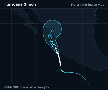
Where forecast positions crowd, a later one is drawn as a small ring without its label, or not at all; the table lists every position.
Land: Natural Earth.
Sustained wind, kt, at the times in the table
| Time | Location | Sustained wind | Classification |
|---|---|---|---|
| Advisory valid | 19.2°N, 105.3°W | 125 kt · 145 mph · 230 km/h | Category 4 hurricane |
| Forecast for | 19.9°N, 105.6°W | 105 kt · 120 mph · 195 km/h | Category 3 hurricane |
| Forecast for | 20.5°N, 106.0°W | 85 kt · 100 mph · 155 km/h | Category 2 hurricane |
| Forecast for | 21.1°N, 106.4°W | 70 kt · 80 mph · 130 km/h | Category 1 hurricane |
| Forecast for | 21.8°N, 106.8°W | 60 kt · 70 mph · 110 km/h | Tropical storm |
| Forecast for | 22.5°N, 106.9°W | 50 kt · 60 mph · 95 km/h | Tropical storm |
| Forecast for | 23.0°N, 106.9°W | 50 kt · 60 mph · 95 km/h | Tropical storm |
| Forecast for | 23.9°N, 106.4°W | 30 kt · 35 mph · 55 km/h | Post-tropical cyclone |
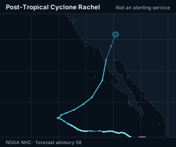
Not available for this advisory: forecast positions.
Land: Natural Earth.
| Time | Location | Sustained wind | Classification |
|---|---|---|---|
| Advisory valid | 35.8°N, 114.6°W | 30 kt · 35 mph · 55 km/h | Post-tropical cyclone |
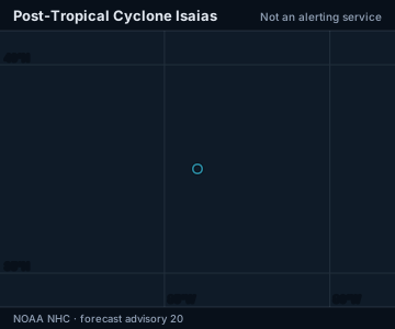
Not available for this advisory: past track, forecast positions, cone.
Land: Natural Earth.
| Time | Location | Sustained wind | Classification |
|---|---|---|---|
| Advisory valid | 37.5°N, 84.0°W | 20 kt · 25 mph · 35 km/h | Post-tropical cyclone |
Tropical cyclones
Filter and sort: Tropical cyclones
Filtering and sorting need JavaScript.
Severe storms
Filter and sort: Severe storms
Filtering and sorting need JavaScript.