
Tropical cyclone
Post-Tropical Cyclone Rachel
Not an alerting service. Follow your national weather service and local authorities.
- Sustained wind
- 30 kt35 mph · 55 km/h · 1-minute average
- Gusts
- 40 kt45 mph · 75 km/h
- Central pressure
- 994 mb (hPa)
- Movement
- NNE 15° at 25 kt29 mph · 46 km/h
Advisory valid 2026-10-11 15:00 UTC
- Location
- About 255 mi (415 km) NNE of San Diego California · 35.8°N, 114.6°W
Where each figure comes from
NHC public advisory 58 · 2026-10-11 15:00 UTC
NHC forecast advisory 58 · 2026-10-11 15:00 UTC
NHC's current storm list · 2026-10-11 15:00 UTC
GDACS alert: Green, no or limited need for humanitarian assistance expected. It estimates humanitarian impact, not storm strength. GDACS event maximum wind (may include forecast): 194 km/h · 105 kt · 121 mph; averaging period not supplied.
Updated by GDACS: 2026-10-11 17:27 UTC
What this tells you
Measured from GDACS's reported point, 35.8°N, 114.6°W, not from NHC's position above. Proximity does not establish exposure.
- Nearest indexed city
- Henderson, United States · 43 km
- People nearby
- 2.6 million in 17 towns and cities within 300 km. Proximity, not people affected. Source: GeoNames indexed cities.
2020 estimates · people/km². Population context, not people affected.
Citation & source notes
- Updated by GDACS
- 2026-10-11 17:27 UTC
- Retrieved by this site
- 2026-10-11 17:37 UTC
- First date GDACS lists for the event
- 2026-09-27 09:00 UTC
- Latest date GDACS lists for the event
- 2026-10-11 15:00 UTC
Published facts in your selected timezone, with original source links. Check the agency for revisions.
Saved places stay in this browser. No account needed.
NHC forecast track
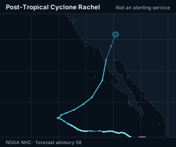
- On the map
- Past track
- Past position
- Cone
- Centre at the advisory's time: depression, low, post-tropical or potential cyclone
- Line width and brightness
- Depression, low, post-tropical or potential cyclone
- Tropical or subtropical storm
- Hurricane
- Major hurricane
The cone contains the probable path of the storm's centre but does not show the size of the storm. Hazardous conditions can occur outside the cone.
Not available for this advisory: forecast positions.
Land: Natural Earth.
| Time | Location | Sustained wind | Classification |
|---|---|---|---|
| Advisory valid | 35.8°N, 114.6°W | 30 kt · 35 mph · 55 km/h | Post-tropical cyclone |
Also tracking near GDACS's reported point: Las Vegas (64 km), Phoenix (350 km), Los Angeles (380 km)
Agency measurements and details
- Alert level
- Green — No or limited need for humanitarian assistance expected
- Country
- Mexico, United States
- GDACS event maximum wind (may include forecast)
- Tropical Depression (maximum wind speed of 194 km/h)
- Updated by GDACS
- 2026-10-11 17:27 UTC
Free for everyone